EarthTime 5.14.3
by DeskSoft
Discover locations around the world and the current time there
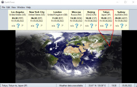
EarthTime software version 5.14.3 is a powerful tool that allows users to visualize changes in the Earth's surface over time. The software provides access to satellite imagery and allows users to view changes in land use, forest cover, and urbanization. It also offers the ability to create custom maps and animations, making it an essential tool for researchers, policymakers, and educators.
EarthTime 5.5.32
(5.7 MB)
EarthTime 5.5.36
(3.91 MB)
EarthTime 5.5.37
(3.91 MB)
EarthTime 5.5.38
(3.91 MB)
EarthTime 5.5.41
(3.92 MB)
EarthTime 5.5.42
(3.92 MB)
EarthTime 5.8.4
(3.96 MB)
EarthTime 5.12.3
(3.97 MB)
EarthTime 5.12.5
(3.97 MB)
EarthTime 5.14.0
(3.99 MB)
EarthTime 5.14.1
(3.99 MB)
EarthTime 5.14.3
(3.99 MB)
EarthTime 5.21.3
(4.01 MB)


