Earthquake 3D
by Starfield-screen-saver
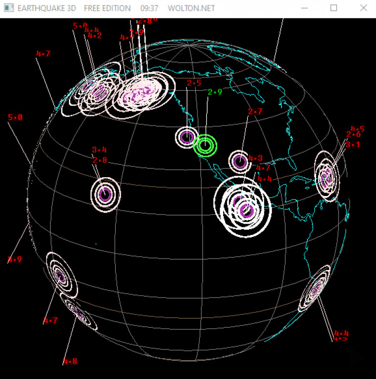
Earthquake 3D is a 3D visualization and analysis tool for exploring, understanding, and analyzing earthquake data.
Operating system: Windows
Publisher: Starfield-screen-saver
Release : Earthquake 3D 2.9
Antivirus check: passed
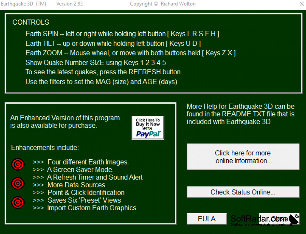
Earthquake 3D is a powerful visualization and analysis software developed to help researchers, geologists, and seismologists understand the complex nature of earthquake data.
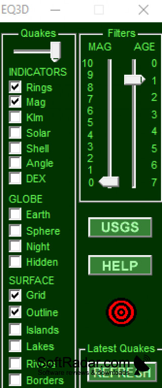
- Data visualization for earthquakes and seismic activity
- 3D data maps and models of earthquake activity
- Powerful data analysis and modeling tools
- Comprehensive library of seismic data
- User friendly and intuitive interface
- Analize seismic activity from multiple data sources
- Customizable visualizations and settings
- Generate reports and export data
Earthquake 3D provides powerful visualizations and analysis of earthquake data, enabling users to gain insight into the behavior of seismic activity. The software allows for the creation of 3D data maps and models that can be used to study the nature of an earthquake. The software also has powerful data analysis and modeling tools, which allow researchers to analyze seismic activity from multiple data sources and draw conclusions.
The user interface of Earthquake 3D is intuitive and user friendly, allowing users to quickly and easily access all the features of the program. Earthquake 3D has a comprehensive library of seismic data, which can be used to study the behavior of seismic activity. The software also has customizable visualizations and settings, which allow users to customize the visualizations to their liking.
Earthquake 3D also has powerful reporting and export features, which enable users to generate reports and export data to other applications. The software also has built-in tools for sharing data with other users, making it easy to collaborate with others. Earthquake 3D is a powerful and versatile software that can be used by researchers, geologists, and seismologists to gain insight into the behavior of seismic activity.
Earthquake 3D software provides a powerful and accurate 3D visualization of seismic activity.Features:
- Data visualization for earthquakes and seismic activity
- 3D data maps and models of earthquake activity
- Powerful data analysis and modeling tools
- Comprehensive library of seismic data
- User friendly and intuitive interface
- Analize seismic activity from multiple data sources
- Customizable visualizations and settings
- Generate reports and export data
Earthquake 3D provides powerful visualizations and analysis of earthquake data, enabling users to gain insight into the behavior of seismic activity. The software allows for the creation of 3D data maps and models that can be used to study the nature of an earthquake. The software also has powerful data analysis and modeling tools, which allow researchers to analyze seismic activity from multiple data sources and draw conclusions.
The user interface of Earthquake 3D is intuitive and user friendly, allowing users to quickly and easily access all the features of the program. Earthquake 3D has a comprehensive library of seismic data, which can be used to study the behavior of seismic activity. The software also has customizable visualizations and settings, which allow users to customize the visualizations to their liking.
Earthquake 3D also has powerful reporting and export features, which enable users to generate reports and export data to other applications. The software also has built-in tools for sharing data with other users, making it easy to collaborate with others. Earthquake 3D is a powerful and versatile software that can be used by researchers, geologists, and seismologists to gain insight into the behavior of seismic activity.
1. Operating System: Windows 7 or higher
2. Procesor: Intel Core 2 Duo or AMD Athlon 64X2
3. Memory: Minimum 2GB RAM
4. Graphics Card: Direct X 9 complatible with minimum 512MB RAM
5. DirectX: Direct X 9.0c
6. Hard Drive Space: 2GB of disck space
2. Procesor: Intel Core 2 Duo or AMD Athlon 64X2
3. Memory: Minimum 2GB RAM
4. Graphics Card: Direct X 9 complatible with minimum 512MB RAM
5. DirectX: Direct X 9.0c
6. Hard Drive Space: 2GB of disck space
PROS
Provides real-time, 3D visualization of global seismic activity.
Easy-to-use interface with customizable settings.
Supports multiple data sources, enhancing accuracy and breadth of information.
Easy-to-use interface with customizable settings.
Supports multiple data sources, enhancing accuracy and breadth of information.
CONS
Lacks real-time earthquake notification features.
3D graphics are somewhat dated.
Frequent updates may disrupt usage.
3D graphics are somewhat dated.
Frequent updates may disrupt usage.
Earthquake 3D 2.9
(1.23 MB)
Earthquake 3D 2.43
(0.83 MB)